Enhancing Safety and Efficiency: How Geofencing by HUMANAV supports Humanitarian organizations Worldwide
27 November 2023 - Humanitarian & Key accounts
27 November 2023 - Humanitarian & Key accounts
UN Humanitarian agencies & Non-Governmental Organizations (NGOs) play a crucial role in providing aid, support, and assistance to vulnerable communities and addressing critical global issues. These organizations often operate in diverse and challenging environments, ranging from remote regions to disaster-stricken areas.
To ensure the safety of their personnel and optimize their operations, Humanitarian organizations have turned to innovative technologies like geofencing, a feature offered by CLS.
Geofencing is a location-based service that uses real time GPS location of vehicle transmitted by the VTS (Vehicle Tracking System) and compare it with virtual boundaries around specified geographical areas created in HUMANAV Platform. CLS HUMANAV Solution, a renowned provider of cutting-edge tracking and safety solutions, has integrated geofencing capabilities into its platforms, supporting Humanitarian organizations to conduct their operations.
Humanitarian organizations often operate in regions affected by conflict, natural disasters, or political unrest, exposing their personnel to potential risks and threats.
As vehicles equipped with VTS (Vehicle Tracking System) approach these zones, real-time alerts are triggered, warning relevant people as Fleet Manager or Security officer about the potential danger. This feature enables Humanitarian organizations to steer clear of unsafe regions, reducing the risk of accidents, injuries, and potential damage to personnel.
Get more information about HumaNav
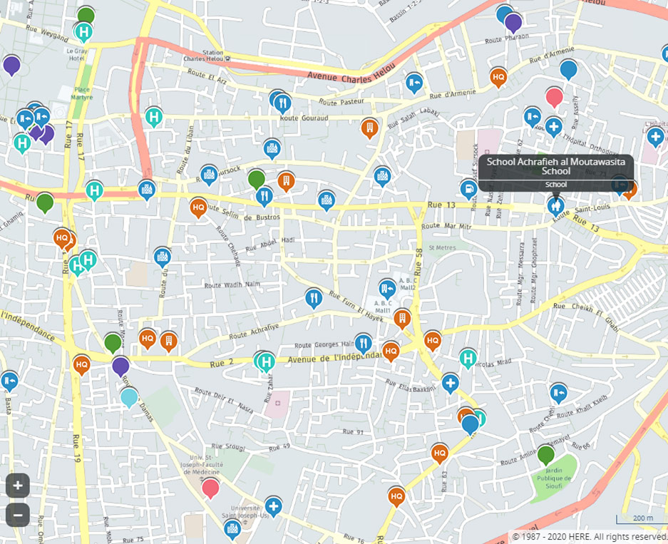
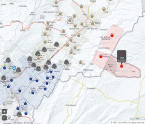
Safety is of paramount importance for Humanitarian organizations, as their personnel travel over varied terrains and challenging conditions. The geofencing feature provided by HUMANAV offers several safety-enhancing benefits, especially thanks to the zone’s categorization.
In fact, it is possible to define the risk level of certain zones and divide them into categories.
Drivers are thus able to avoid certain high-risk areas such as Red Zones, but also identify where points of interest such as schools, medical clinics etc. are located.
Efficient itinerary planning is crucial for Humanitarian organizations to optimize their resources and deliver effective aid. Geofencing provides real-time tracking of vehicles within the defined boundaries, allowing Humanitarian organizations to monitor their fleet’s movements closely thanks to corridoring and route management. This information helps organizations to identify any deviations from the planned route, enabling them to intervene and address potential issues promptly.
The geofencing feature provided by CLS HUMANAV Solutions can be used as a key tool for Humanitarian organizations worldwide, contributing significantly to the safety and efficiency of their operations. By helping NGOs to avoid dangerous zones, increase driver safety, and track itineraries, geofencing enables these organizations to provide effective help and support to vulnerable communities.
But as we know, aid workers are often transferred to a new crisis or war zone at a moment’s notice.
That’s why CLS is constantly enhancing its HUMANAV solution in line with agencies’ evolving needs, and why the latest upgrades to its SOS function aim to further protect worker and asset safety.